
GR11 E9 - Calhau da Cova
Route from the village of Sesimbra to the east, along the coastal cliff, to the site of the old fishing frame of Calhau da Cova.
Go to the end: Armação do Calhau da Cova
1:00 | 3 |
GR 11 - Caminho do Atlântico
Along the coastal cliff, between 80 and 170 meters in altitude, descending in the final part to the sea.
GR11 E9 – Calhau da Cova (2.9 km)
Depart from the east end of Sesimbra, in the middle of the cliff, at the end of a small street that descends from Estrada de Argeis. And follow the cliff, over the sea, to the east.
On Earth, the continental plates flow over a viscous magma always in motion. About 225 million years ago, these plates formed an immense continent, Pangeia. This continent was later divided into Laurasia, to the north, and Gondwana, to the south. The Mediterranean is a remnant of the Tethys Sea, which divided these two continents. The Atlantic then opened up, first dividing Gondwana on the South American and African continents, then progressing north and dividing Laurasia on the North American and Eurasian continents.

130 million years ago, the Atlantic rift progressed from south to north, passing the Azores-Gibraltar fault. 120 million years ago, the next barrier in the S-N progression of the opening of the North Atlantic was the huge fault of Arrábida, which is now hidden here along the southern edge of the Setúbal peninsula. Successive failures perpendicular to the rift can still be identified on the Portuguese coast today (Arrábida failure, Nazaré failure, Aveiro failure).

Laurasia's continental punch thus broke, slowly but inexorably. Shattered, the continental punch, on the Setúbal peninsula, rises from the Tagus estuary to the south, under the terrain, until it breaks in these cliffs where we are. Here, south of these cliffs, a huge fault breaks the continental punch in the W-E direction. To the south, the continental punch rises from west to east, under the sea that bathes Alentejo, appearing at the surface in the Serra de Grândola, on the horizon.


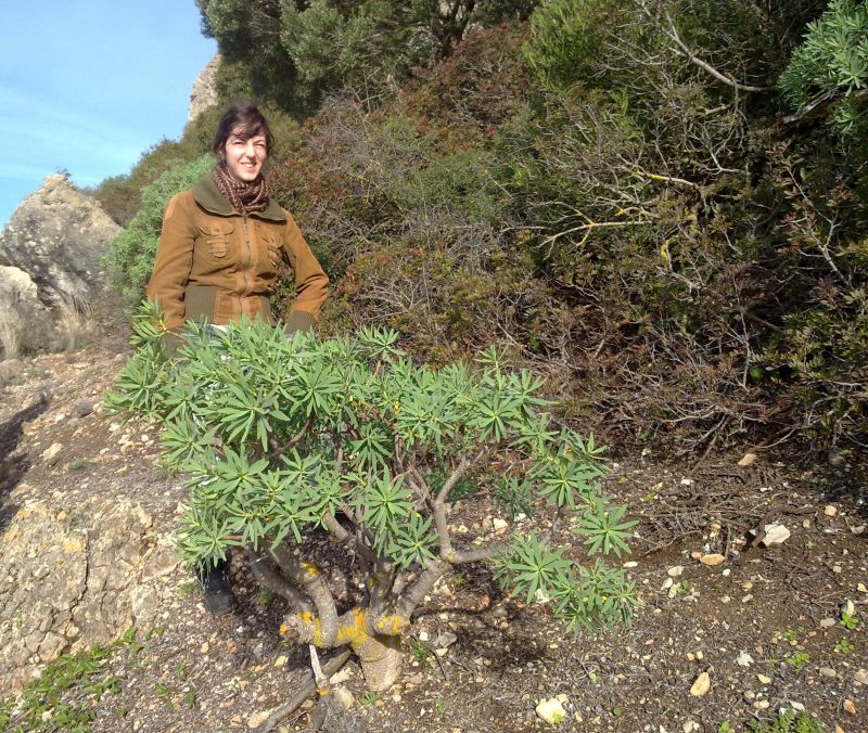
These cliffs also hide a sacred legacy, a vestige of the tertiary reliquial paleotropical xerophytic/semi-desert flora: the “Arrábida euphorbia woods”. These limestone rocky cliffs are home to crassicaule shrub communities dominated by the Euphorbia pedroi, which exists exclusively at these maritime cliffs, from Cabo Espichel to Serra da Arrábida, living together with Juniperus turbinata, olives (Olea europaea), mastics (Pistacia lentiscus) or Mediterranean buckthorns (Rhamnus oleoides). The Convolvulus fernandesii also occurs in these communities, of which only small nuclei are known. Trampling in these areas can harm plants and their survival, as some nuclei are isolated and have a low number of individuals. Access is therefore conditioned.
The Euphorbia pedroi is limited to the limestone cliffs between Sesimbra and Cabo Espichel. It is the only representative in Portugal of the shrub euphorbia group. This group of euphorbias has a great diversity of species in Madeira, the Canaries, Cape Verde, the Mediterranean coast, the African coast and the Arabian Peninsula. When observing the place, you will understand that these limestone cliffs, facing south, protected from the north wind and with high insolation, formed for millions of years an ecological niche that escaped the most diverse environmental cataclysms and allowed this euphorbia, separated from its sisters, survive on a limestone substrate that was favorable to it. The separation led to its differentiation from other tropical species, including Euphorbia dendroides, which occurs from the Iberian Peninsula to Egypt.
The Convolvulus fernandesii is limited to the limestone coastal cliffs located on the south-facing coast between Sesimbra and Cabo Espichel. It is a neo-endemism whose ancestor colonized the Portuguese coast after the end of the last glaciation. It occurs forming aggregates, in crevices of compact outcropping limestones, along the Jurassic limestone-dolomitized cliffs. Sometimes it is suspended in thickets of sclerophytic vegetation, adopting creeper behavior. Unauthorized climbing and abseiling activities can lead to the disappearance of this species, and should be avoided completely in this area.

Figure 1 - From O Botânico Aprendiz
Then follow the half-cliff path in the east direction. At 38.4394, -9.0856 turn north and go up to the crest of the cliff by west. You will eventually reach the plateau over the sea. Wild boars, in their search for bulbs and other buried plant species, may have tossed the soil. This promotes aeration of the soil and promotes the birth of new trees and shrubs, but do not forget that the boar is extremely protective and can invest in any threat to its offspring, including against humans. The active period of wild boars is, however, mainly nocturnal.

Now head east, along the cliff crest. You will end up passing by a watchtower, where a mandador tried to locate a school of tuna, then descending to the village so that the school was surrounded by one of the armações of Sesimbra.
Always continue to the east, along the path, cross a gravel zone, and, at the end, go down to Calhau da Cova, beyond Cabo de Ares, in a small bay that ends at Ponta de São Pedro.
The almadravas were mobile fishing frames that were introduced in the bay of Sesimbra around the 13th or 14th centuries, at the initiative of the king D. Dinis. Made for tuna fishing, it could, however, catch other large specimens, namely swordfish. In the 17th century, there were 6 fishing frames in the area, capturing schools of tuna that was going to spawn in the Mediterranean and return. These important fishing gears operated in Sesimbra until the 60s of the 20th century. They were composed of a complex set of nets and cables, supported by a no less complex system of anchors or irons, and difficult to assemble. They were of great importance in the local economy, due to the volume of fish. The company of each armação was made up of about 50 men.
The armação da Cova was here, where the tour ends, and you can still see the walls that protected the equipment during the winter. It was granted to Joaquim Gomes de Loureiro in the middle of the 19th century.
GR11 E9 – Calhau da Cova (2,9 km)
Parta da extremidade nascente de Sesimbra, a meio da falésia, no final de uma pequena rua que desce da Estrada de Argeis. E siga pela arriba, sobre o mar, para nascente.
Na Terra, as placas continentais sobrenadam um magma viscoso sempre em movimento. Há cerca de 225 milhões de anos essas placas formaram um imenso continente, a Pangeia. Este continente dividiu-se depois na Laurasia, a norte, e Gondwana, a sul. O Mediterrâneo é um resto do Mar de Tétis, que dividia esses dois continentes. Abriu-se depois o Atlântico, primeiro dividindo Gondwana nos continentes sul-americano e africano, depois progredindo para norte e dividindo a Laurasia nos continentes norte-americano e euroasiático.
Há 130 milhões de anos, o rift atlântico progredia de sul para norte passando a falha Açores-Gibraltar. Há 120 milhões de anos, a barreira seguinte na progressão S-N da abertura do Atlântico Norte era a enorme falha da Arrábida, que se esconde agora aqui ao longo do bordo sul da península de Setúbal. Sucessivas falhas perpendiculares ao rift ainda hoje se podem identificar na costa portuguesa (falha da Arrábida, falha da Nazaré, falha de Aveiro).
O soco continental da Laurasia foi assim quebrando, lenta mas inexoravelmente. Estilhaçado, o soco continental, na península de Setúbal, ergue-se do estuário do Tejo subindo para sul, sob o terreno, até quebrar nestas arribas onde estamos. Aqui, a sul destas arribas, uma falha enorme parte o soco continental na direção E-W. A sul, o soco continental sobe depois de poente para nascente, sob o mar que banha o Alentejo, aparecendo á superfície na Serra de Grândola, no horizonte.
Estas arribas escondem ainda um legado sagrado, um vestígio da flora xerofítica/semi-desértica paleotropical reliquial terciária: os “matos de eufórbias da Arrábida”. Estas falésias rochosas calcárias abrigam comunidades arbustivas crassicaules dominadas pelo trovisco-do-Espichel que se distribuem exclusivamente por estas arribas marítimas, desde o Cabo Espichel até à Serra da Arrábida, incluindo-se nelas frequentemente sabinas-negral (Juniperus turbinata), zambujeiros (Olea europaea), aroeiras (Pistacia lentiscus) ou espinheiros-preto (Rhamnus oleoides). Ocorre ainda nestas comunidades a corriola-do-Espichel, de que apenas são conhecidos pequenos núcleos. O pisoteio nestas áreas pode prejudicar as plantas e a sua sobrevivência, dado alguns núcleos estarem isolados e possuírem um baixo número de indivíduos. O acesso está, pois, condicionado.
O trovisco-do-Espichel (Euphorbia pedroi) está circunscrito às arribas e escarpas marítimas de calcário, entre Sesimbra o Cabo Espichel. É o único representante em Portugal do grupo das eufórbias arbustivas. Este grupo das eufórbias tem grande diversidade de espécies na Madeira, Canárias, Cabo Verde, costa mediterrânica, costa africana e Península Arábica. Ao observar o local, compreenderá que estas arribas calcárias, viradas a sul, protegidas do vento norte e com elevada insolação, formaram durante milhões de anos um nicho ecológico que escapou aos mais diversos cataclismos ambientais e permitiu que esta eufórbia, separada das suas irmãs, sobrevivesse num substrato calcário que lhe era favorável. A separação levou à sua diferenciação das outras espécies, tropicais, inclusive da Euphorbia dendroides, que ocorre desde a Península Ibérica até ao Egito.
A corriola-do-Espichel (Convolvulus fernandesii) está circunscrita às arribas costeiras calcárias localizadas na costa virada a sul entre Sesimbra e o Cabo Espichel. É um neo-endemismo cujo ancestral colonizou a costa portuguesa após o final da última glaciação. Ocorre formando agregados, em fendas de calcários compactos aflorantes, ao longo das arribas calcário-dolomitizadas do Jurássico. Por vezes suspende-se em moitas de vegetação esclerófita adotando comportamento de trepadeira. Atividades de escalada e rappel não autorizadas podem originar o desaparecimento desta espécie, pelo que se devem evitar completamente nesta zona.
Siga então pela vereda a meia-arriba, na direção nascente. Em 38.4394, -9.0856 vire para norte e suba até à crista da arriba por poente. Acabará por chegar ao planalto sobre o mar. Os javalis, na sua procura de bolbos e outras espécies vegetais enterradas, podem ter revolvido o solo. Isto promove o arejamento do solo e propicia o nascimento de novas árvores e arbustos, mas não se esqueça que a javalina é extremamente protetora e pode investir sobre qualquer ameaça à sua prole, inclusive contra o ser humano. O período ativo dos javalis é, no entanto, principalmente noturno.
Siga agora sempre para nascente, ao longo da crista da falésia. Acabará por passar junto a uma atalaia, onde um mandador tentava localizar um cardume de atuns, descendo depois à povoação para que o cardume fosse cercado por uma das armações de Sesimbra.
Continue sempre para nascente, pela vereda, atravesse uma cascalheira, e, no final, desça até à armação do Calhau da Cova, para lá do Cabo de Ares, numa pequena baía que termina na Ponta de São Pedro.
As almadravas eram armações de pesca móveis que foram introduzidas na baía de Sesimbra cerca dos séculos 13 ou 14, por iniciativa de D. Dinis. Destinando-se à pesca do atum, podiam, contudo, capturar outros espécimes de grande porte, nomeadamente espadartes. No século 17 chegaram a existir 6 armações de pesca na zona, capturando os cardumes de atuns que iam desovar ao Mediterrâneo e voltavam. Estas importantes artes de pesca operaram em Sesimbra até aos anos 60 do século 20. Eram compostas por um complexo conjunto de redes e cabos, sustentado por um não menos complexo sistema de âncoras ou ferros, e de difícil montagem. Tinham grande importância na economia local, pelo volume de pescado. A companhia de cada armação era composta por cerca de 50 homens.
A armação da Cova ficava aqui, onde termina o passeio, e ainda se podem ver os paredões que protegiam o equipamento durante o inverno. Foi concessionada a Joaquim Gomes de Loureiro em meados do século 19.